Widespread rain and severe thunderstorm expected over the eastern parts of the country on Thursday.
Image: Freepik
Thursday will bring a sharp weather contrast across South Africa, with widespread and potentially severe thunderstorms expected in the eastern and central interior, while large parts of the Western Cape remain dry and warm.
According to the South African Weather Service (SAWS), the highest rainfall probability exists over KwaZulu-Natal, where widespread rainfall of up to an 80% probability is forecast.
These storms may be intense at times, accompanied by heavy downpours, strong winds, excessive lightning and hail, increasing the risk of flooding in vulnerable areas.
An Orange Level 5 warning for severe thunderstorms is in place for parts of the province, signalling a heightened risk of significant impacts.
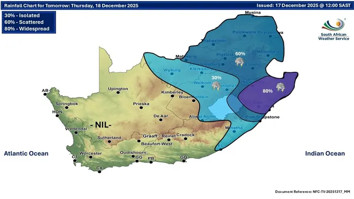
Widespread storms are predicted over the eastern half of South Africa on Thursday.
Image: South African Weather Service (SAWS)
Across Mpumalanga, Limpopo and Gauteng, scattered to widespread showers and thunderstorms are expected, with rain chances ranging between 60% and locally higher. Some of these storms may turn severe, particularly during the afternoon and evening, with damaging winds and hail possible in isolated areas.
The central interior, including parts of the Free State, can expect more isolated activity, with rain chances of around 30%, mainly later in the day.
The Western Cape, including the Cape Winelands and Franschhoek, will remain largely dry with no meaningful rainfall expected.
Skies will be partly cloudy along the coast at times, but interior areas will enjoy mostly fine conditions and mild to warm temperatures, offering a calm break from the stormy weather elsewhere in the country.
Residents in affected eastern regions are urged to stay weather-aware, avoid flooded roads and monitor updates, as thunderstorm activity may intensify rapidly during the peak heat of the day.
IOL News